Austin has demolished over 850 homes along Onion Creek since 1999 because they kept flooding. The city spent more than $100 million buying them, tearing them down, and turning the land back into permanent green space. According to FEMA’s case study on the buyout project, every single acquired structure had to be razed under federal mitigation guidelines.
That’s not me trying to scare you. But if you’re buying a home in Austin flood zone areas, you need to understand what you’re walking into. The 2013 Halloween flood killed five people when Onion Creek rose 41 feet (it jumped 11 feet in fifteen minutes), and the 2015 Halloween flood destroyed another 400 homes in Southeast Austin. This city floods. It floods hard, it floods fast, and it floods in places that look totally dry 364 days a year.
So lets talk about what you actually need to know. The flood maps, the insurance math, the zone designations that matter, and whether buying in a flood zone is a smart discount or a financial trap.
How to Check if an Austin Property Is in a Flood Zone
Before you even get excited about a listing price, check the flood zone. Austin gives you three free tools and you should use all of them (they sometimes show different things, which I’ll explain in a second).
Tool 1: FEMA’s Flood Map Service Center at msc.fema.gov. Type in the address, get the official FEMA flood zone designation. This is the map your lender will use to decide if you need flood insurance. Its the federal baseline.
Tool 2: City of Austin FloodPro at austintexas.gov. This is the one most people skip and its the most important one. Austin maintains its own regulatory floodplain maps that are often MORE restrictive than FEMA’s maps. The city has done more detailed modeling of local creek systems and their maps frequently show a larger flood risk area than what FEMA shows. If you only check FEMA, you might miss that Austin considers your property at risk.
Tool 3: Texas Flood Information Viewer at map.texasflood.org. State-level tool, good for seeing the broader watershed picture and how waterways connect across Central Texas.
Here’s why you check all three. FEMA updates its maps periodically but Austin’s Watershed Protection Department has been running their own studies and expects updated flood models by mid-2026. A property that’s currently Zone X on FEMA’s map could get reclassified. I’ve seen it happen. And when it does, your insurance requirements (and costs) change pretty much overnight.
What Zone X, Zone A, and Zone AE Actually Mean
Ok so you pulled up the flood map and you see letters. Lets decode them because this directly affects your wallet.
Zone X (unshaded) is what everyone wants. Minimal flood risk. No insurance requirement. You can still flood here though. About 20% of NFIP flood claims come from Zone X properties, which is a stat that surprises most people. But your lender won’t force you to carry a policy, and the premiums if you voluntarily buy coverage are pretty reasonable.
Zone X (shaded) is the 500-year floodplain. A 0.2% annual chance of flooding. Sounds tiny right. But over 30 years it adds up more than you’d think. No insurance requirement from lenders, but I’d strongly recommend it. The premiums are still manageable and one flood event without coverage will cost you way more than 30 years of premiums combined.
Zone A is where things get serious. This is the 100-year floodplain. A 1% annual chance of flooding. And here’s the number that gets people: that translates to a 26% chance of flooding during a 30-year mortgage. One in four. If your lender is federally regulated (and most are), flood insurance is mandatory. Zone A means FEMA hasn’t done detailed elevation analysis yet, so there are no Base Flood Elevations established.
Zone AE is the same 1% annual risk as Zone A but FEMA has done detailed studies and established Base Flood Elevations (BFEs). This is actually useful information for you as a buyer because the BFE tells you exactly how high floodwaters are expected to reach. If the home’s lowest floor is above the BFE, your insurance premiums will be significantly lower than a home sitting below it.
Nassim Taleb wrote about how humans are terrible at understanding low-probability, high-consequence events. He called them Black Swans. Flood risk is exactly that kind of thing. A 1% annual chance sounds like nothing until you realize you’re rolling that dice every single year for decades.
What Flood Insurance Actually Costs in Austin
Lets talk money because this is where the deal math either works or falls apart.
The average NFIP flood insurance premium in Texas runs about $700 to $779 per year according to FEMA data. Nationally the average is about $926. But that statewide average is almost meaningless for your specific property because FEMA rolled out Risk Rating 2.0, and now every property gets individually assessed based on flood frequency, the type of flood source, distance to water, and the cost to rebuild.
For a home in a moderate-risk Zone X (shaded) area in Austin, you’re probably looking at $400 to $700 annually. Not bad. For a Zone A or AE property, expect $800 to $1,500 or more depending on the structure’s elevation relative to the BFE.
And here’s what a lot of buyers miss. Flood insurance is completely separate from your homeowners insurance. Your standard homeowners policy does not cover flood damage. Period. So you’re adding this cost on top of what’s already a significant annual expense in Texas (we pay some of the highest property insurance rates in the country).
When I’m running numbers with buyers, I always add the flood premium to the monthly carrying cost. On a $400,000 home in Zone AE, an extra $1,200 a year in flood insurance adds $100 a month to your total housing cost. That changes your effective buying power. If you’re already stretched on the income needed to buy in Austin, this is not a line item you can just ignore.
Austin’s Flood History: Why This City Is Different
Austin sits at the eastern edge of the Texas Hill Country where the limestone terrain drops into the Blackland Prairie. When it rains hard, water runs fast off the rocky hills and has nowhere to go. Over 40% of Austin’s surface is impervious cover (rooftops, roads, parking lots), and that percentage keeps growing as the city develops. More concrete means faster runoff. Faster runoff means worse flooding.
Onion Creek: The Big One
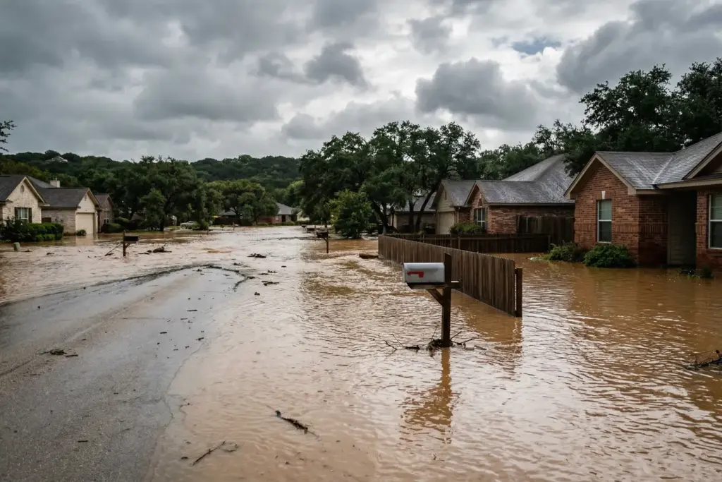
Onion Creek in Southeast Austin is the most notorious flood zone in Central Texas. On Halloween 2013, nearly 10 inches of rain fell in 24 hours. The creek rose from normal levels to 41 feet, setting an all-time record that topped a mark from 1921 by three feet. Not over hours. Over minutes. Five people died. More than 500 homes were damaged.
Two years later, almost to the day, it happened again. The 2015 Halloween flood dumped 10 to 12 inches of rain on the same watersheds. Three more people died. About 400 homes were damaged or destroyed.
The city’s response was the largest flood buyout program in Austin’s history. Since 1999, Austin has purchased over 850 homes along lower Onion Creek through its Watershed Protection Department. Every home gets demolished. The land becomes permanent green space under federal rules. The city authorized $60 million for buyouts in September 2014, with additional phases totaling another $45 million. The whole point was simple: stop building where the water goes.
If you’re looking at properties near Onion Creek in 78745 or 78748, pay very close attention to the flood maps. Some areas that flooded have been cleared entirely. Others are still occupied and still carry risk.
Shoal Creek: Right Through Downtown
Shoal Creek runs through some of the most expensive real estate in central Austin, which is the kind of irony that real estate always seems to deliver. The 1981 Memorial Day flood killed 13 people along Shoal Creek. The 2022 overflow caused landslides, road closures, and evacuations.
According to the City of Austin, more than 75 buildings in the lower Shoal Creek area are still vulnerable to a 100-year flood event. These aren’t cheap properties either. Some of the most walkable, desirable neighborhoods in Austin sit right along this corridor.
Other Creeks You Should Know About
Williamson Creek in South Austin has flooded seriously in 1998, 2001, and 2013. Its a quieter creek that doesn’t get the headlines Onion Creek does, but the risk is real and the neighborhoods along it are popular with buyers.
Bull Creek near Spicewood Springs Road in Northwest Austin floods during heavy rain events. If you’re looking at properties near 360 and Spicewood Springs, check the maps.
Even Barton Creek, which feeds into Lady Bird Lake through some of Austin’s most beloved neighborhoods, has flood-prone sections along its corridor.
The pattern is simple and its not going to change. Austin’s creek system is extensive, every creek has flooded at some point, and the combination of steep terrain, impervious surfaces, and increasingly intense storms makes this a structural problem. Not a one-time event.
How Flood Zones Affect Property Values and Resale
Now lets get to what some of you are really thinking about. The money.
Research from the National Bureau of Economic Research found that homes in the 100-year floodplain sell for 4.4% to 13.3% less than comparable properties outside the flood zone. After Hurricane Harvey hit Houston, Freddie Mac data showed floodplain home values dropped an additional 3.1%, which worked out to about $10,125 on the average Harris County home.
So yes, you will likely get a discounted purchase price in a flood zone. But here’s what that discount is pricing in.
Higher carrying costs. Mandatory flood insurance adds $800 to $1,500+ annually. Over a 10-year hold thats $8,000 to $15,000 that comparable non-flood-zone properties don’t pay.
Smaller buyer pool on resale. When you sell, many buyers will pass on flood zone properties entirely. The ones who are interested will negotiate harder and may demand a thorough home inspection that goes beyond the standard scope.
Disclosure requirements. Texas requires sellers to disclose known flooding history. If the home has flooded before, that disclosure follows the property forever. You could do $50,000 in mitigation work and the flooding history still goes on the seller’s disclosure. Its a permanent footnote.
Potential reclassification. FEMA maps get updated. A property that’s Zone X today could become Zone A when new models are published. Austin expects updated flood models by mid-2026, and some properties will see their risk designation change. If yours gets reclassified into a higher-risk zone, your insurance costs jump and your property value takes a hit at the same time.
But here’s the thing. Not every flood zone property is a bad buy. Some sit at the edge of a flood zone on higher ground. Some have been elevated or had significant mitigation work done. Some are priced so aggressively that the math works even with insurance factored in. The key is running the actual numbers instead of just seeing “flood zone” and panicking.
Practical Advice for Buyers Considering a Flood Zone Property
If you’re looking at a flood zone property in Austin, here’s what I walk my buyers through. I’ve done this enough times that the checklist is pretty battle-tested at this point.
Get an Elevation Certificate. This document tells you exactly how high the home sits relative to the Base Flood Elevation. If the structure is above the BFE, your insurance premiums drop dramatically and your actual flood risk is lower than the zone designation suggests. The seller may already have one. If not, a surveyor can produce it for $500 to $1,000. Worth every penny.
Price flood insurance BEFORE you make an offer. Don’t wait until you’re under contract to find out what the premium is. Call an insurance agent, give them the address, and get a real quote. Then add that number to your monthly cost calculation. If the total housing cost pushes past what’s comfortable, either adjust your offer price or walk. The full Austin home buying process has a lot of moving pieces and insurance is one you want nailed down early.
Research the actual flood history. Has this specific property flooded before? Has the street flooded? Ask the neighbors. Seriously, just knock on a door and ask. Check the city’s FloodPro tool for historical flood extent data. A property that’s technically in a flood zone but has never actually flooded is a very different proposition than one that’s been underwater twice.
Understand what mitigation has been done. Has the home been elevated? Are there flood vents in the foundation? Has the landscaping been graded to direct water away from the structure? These improvements affect both your risk and your insurance premium.
Think about the long game. If you’re buying as a short-term hold of 3 to 5 years, the resale risk is real and probably not worth the headache. But if this is your forever home and the location is right, the insurance is manageable, and the property has good elevation, the zone designation alone shouldn’t kill the deal.
Factor in climate trends. Austin’s storms are getting more intense. The city knows this, which is why they keep updating their flood models. Properties that have been fine for 20 years could face increased risk going forward. This isn’t doom and gloom, its just practical planning. Benjamin Graham’s whole framework was about building a margin of safety into every investment decision. Same principle applies here. Don’t buy at the absolute edge of what you can afford when there’s a known risk variable you can’t control.
Frequently Asked Questions
Should You Buy in an Austin Flood Zone?
I’m not going to tell you to never buy in a flood zone. That would be lazy advice and it would be wrong. Some of the best located properties in Austin sit near water, and the creeks are part of what makes this city what it is. Onion Creek, Shoal Creek, Barton Creek, Bull Creek. They define the neighborhoods.
But you need to go in with your eyes open. Check all three flood maps. Get the elevation certificate. Price the insurance before you fall in love with the kitchen. Run the total cost of ownership numbers and compare them honestly to what you’d pay for a comparable home on higher ground.
The buyers who get burned are the ones who ignore the flood zone designation because the price looked too good. The 4% to 13% discount exists for a reason. Your job is to figure out whether that reason is a manageable annual cost (insurance premiums on a well-elevated home) or an unmanageable risk (a creek that’s 50 feet from your living room and has flooded three times in the last decade).
If you want help evaluating a specific property’s flood risk, reach out. I’ve been working this market for 19 years and I know which streets flood, which neighborhoods have been mitigated, and where the updated flood models are likely headed. At Neuhaus Realty Group, that’s exactly the kind of local knowledge we build into every buyer’s search. Browse Austin homes for sale whenever you’re ready to start looking.


