
Austin’s Most Walkable Neighborhoods: The Complete 2026 Ranking
Homes in Austin’s most walkable neighborhoods can sell for a meaningful premium over comparable properties in car-dependent areas. That premium translates to as much as $3,000 in additional home value for every single point of Walk Score, a metric that rates addresses on a 0-to-100 scale based on how many everyday destinations fall within walking distance.
Austin as a whole scores just 42 out of 100, placing it firmly in “car-dependent” territory (Source). But that city-wide number hides a dramatic divide. A handful of central neighborhoods score 80 or above, putting them on par with walkable pockets of Portland, Denver, and Nashville. The catch? Those neighborhoods also carry some of the highest price tags in the metro.
According to the National Association of Realtors’ Community and Transportation Preferences Survey, about 60% of Americans say they prefer neighborhoods with a mix of homes, stores, and other businesses over strictly residential subdivisions (Source). In Austin, where traffic congestion regularly ranks among the worst in Texas, that preference is translating into real buying behavior.
This guide ranks every walkable neighborhood in Austin by the numbers, breaks down what you can actually buy in each one, and identifies where walkability is headed over the next decade as Project Connect light rail reshapes the city.
What Walk Score Actually Measures (and What It Misses)
Walk Score is the most widely cited walkability metric in real estate. The algorithm analyzes walking routes to nearby amenities across categories including grocery stores, restaurants, shopping, coffee shops, banks, parks, schools, and entertainment. It also factors in population density, intersection density, and average block length. Scores break down into five tiers:
| Walk Score | Description | What It Means |
|---|---|---|
| 90-100 | Walker’s Paradise | Daily errands do not require a car |
| 70-89 | Very Walkable | Most errands can be accomplished on foot |
| 50-69 | Somewhat Walkable | Some errands can be accomplished on foot |
| 25-49 | Car-Dependent | Most errands require a car |
| 0-24 | Almost All Errands Require a Car | Minimal walkable infrastructure |
Walk Score pulls data from Google, OpenStreetMap, the U.S. Census, and Localeze, among other sources. The algorithm is useful but imperfect. It does not account for sidewalk quality, how many lanes of traffic you have to cross, crime rates, shade, elevation changes, or weather. In Austin, where summer temperatures routinely exceed 100 degrees, that last omission matters. A neighborhood with a Walk Score of 80 but zero tree canopy feels very different in August than one with mature live oaks lining every block.
Two companion scores round out the picture. Transit Score measures access to public transportation, factoring in the frequency and type of nearby transit routes. Bike Score evaluates bike infrastructure including lanes, trails, hills, road connectivity, and bike commuting mode share. In Austin, Bike Score often outpaces Walk Score thanks to the city’s extensive trail network and the $460 million Prop B bike infrastructure investment voters approved in 2020.
Austin’s Top Walkable Neighborhoods: The Complete Ranking
The following table shows every Austin neighborhood that scores 70 or higher on Walk Score, along with Transit Score, Bike Score, and approximate 2026 median home prices based on Austin Board of Realtors and MLS data.
| Neighborhood | Walk Score | Transit Score | Bike Score | Median Price (2026) |
|---|---|---|---|---|
| West Campus | 92 | 65 | 94 | $350K-$500K (condos) |
| Downtown | 89-94 | 72 | 93 | $400K-$700K (condos) |
| North University | 84 | 66 | 92 | $500K-$800K |
| East Cesar Chavez | 84 | 49 | 93 | $550K-$850K |
| Central East Austin | 84 | 53 | 85 | $500K-$750K |
| Bouldin Creek | 82 | 54 | 78 | $979K |
| Holly | 82 | 49 | 94 | $600K-$900K |
| Hancock | 79 | 60 | 90 | $650K-$850K |
| Hyde Park | 78 | 56 | 94 | $785K-$800K |
| Chestnut | 78 | 53 | 90 | $450K-$700K |
| Zilker | 75 | 47 | 82 | $900K+ |
| Upper Boggy Creek | 73 | 54 | 85 | $475K-$700K |
| Dawson | 71 | 49 | 67 | $550K-$750K |
| Brentwood | 70 | 54 | 83 | $650K-$850K |
| Crestview | 70 | 52 | 87 | $600K-$800K |
| Rosedale | 70 | 45 | 81 | $700K-$1M |
| Rosewood | 70 | 50 | 86 | $400K-$650K |
A few things jump out immediately. Bike Score consistently runs higher than Walk Score across nearly every neighborhood. Austin is a better biking city than a walking city, and that gap is widening as the city adds protected lanes and trails. Transit Score lags behind both, reflecting Austin’s limited bus-only public transit system (though that changes when Project Connect light rail arrives).
Downtown Austin: Walk Score 89-94
Downtown earns the highest Walk Score in Austin, and it is one of the only places in the city where you can genuinely live without a car. The Second Street District, the Warehouse District, Rainey Street, and the Convention Center area all cluster around a 94 Walk Score. Grocery options include the Whole Foods flagship on Lamar (the company’s global headquarters) and multiple convenience markets. Restaurants, bars, coffee shops, and entertainment are abundant in every direction.
The trade-off is price and space. Downtown living means condos or apartments, with median condo prices ranging from $400,000 to $700,000 depending on the building and floor. High-rise towers like The Independent, 70 Rainey, and the Austonian offer luxury living with amenities, but monthly HOA fees run $400 to $1,200. For a deeper look at condo ownership, see the Complete Guide to Buying a Condo in Austin.
Parking is expensive (often $200 to $350 per month in garages), which makes the walkability less of a lifestyle choice and more of a financial necessity. Transit access is the best in the city, with CapMetro’s highest-frequency bus routes and the future Project Connect light rail running directly through downtown.
Best for: Young professionals, remote workers who want urban energy, retirees who have downsized and want to walk to restaurants, concerts, and cultural events.
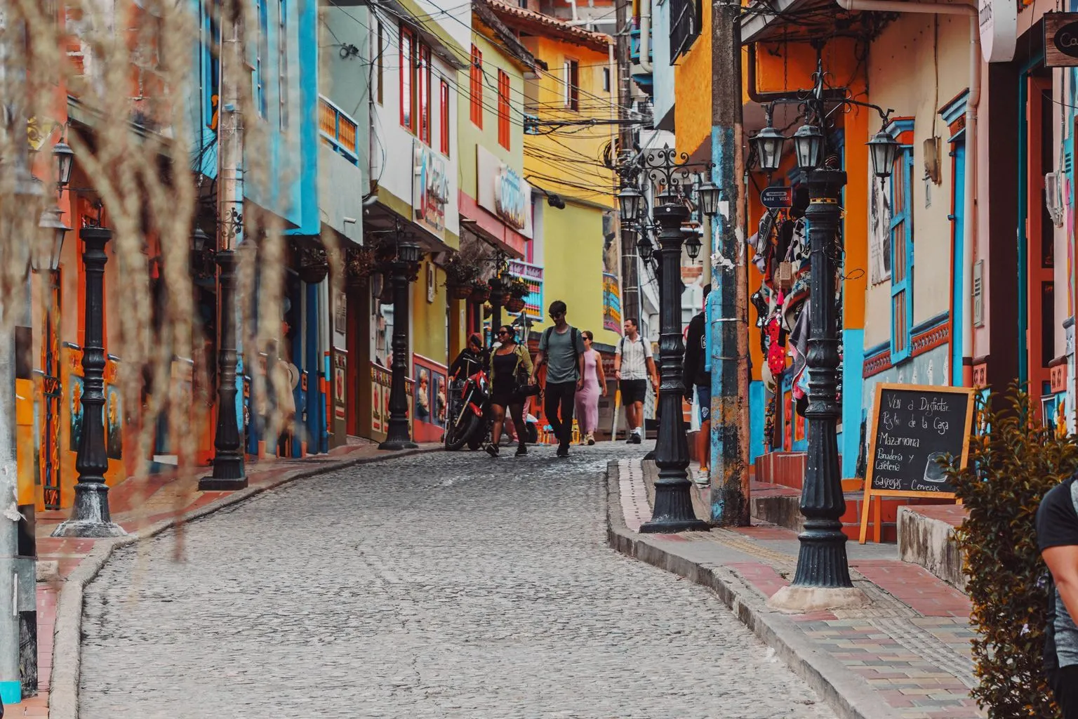
East Cesar Chavez and East Austin: Walk Score 84
East Austin is the most walkable neighborhood in Austin outside of the university area and downtown, and it offers something the other high-scoring areas do not: single-family homes with yards. East Cesar Chavez scores an 84 Walk Score with a 93 Bike Score, making it one of the best-connected neighborhoods for non-car transportation.
The walkable spine runs along East 6th Street, East Cesar Chavez, and Holly Street. Within a 10-minute walk of most homes, you will find taco shops, craft breweries, coffee roasters, boutiques, art galleries, and some of the best barbecue in the city. Franklin Barbecue is technically just across I-35 in the Holly neighborhood, which carries its own Walk Score of 82.
Median home prices in East Austin range from $500,000 to $750,000 for single-family homes, with some newer construction pushing above $850,000. Prices dropped 11.5% year-over-year in early 2026, according to Austin Board of Realtors data, making this one of the few highly walkable neighborhoods where buyers have some leverage.
The gentrification story is impossible to ignore. East Austin has transformed dramatically over the past 15 years, with longtime residents displaced by rising property values. That process has created the walkable infrastructure (restaurants, shops, coffee spots) that now attracts buyers, but it has also changed the neighborhood’s character. New construction tends to be modern duplexes and townhomes on subdivided lots, often built to the property line with minimal setbacks.
Bike infrastructure is excellent, with protected lanes along several corridors and easy access to the Boggy Creek Trail. Transit is average, with a 49 Transit Score reflecting limited bus frequency outside of peak hours.
Best for: Buyers who want walkability with a yard, creative professionals, food enthusiasts who want to walk to restaurants, and investors looking at the long-term value of walkable housing stock. For more on East Austin’s food and restaurant scene, check out that dedicated guide.
Bouldin Creek and South Congress: Walk Score 82
Bouldin Creek carries an 82 Walk Score, but the real walkability story here is South Congress Avenue, which cuts through the eastern edge of the neighborhood and serves as one of Austin’s most iconic pedestrian corridors. SoCo is lined with boutiques, vintage shops, galleries, food trucks, and restaurants for over a mile. On any given weekend, the sidewalks are packed with locals and tourists walking between Jo’s Coffee, Amy’s Ice Creams, Home Slice Pizza, and dozens of other spots.
The walkable zone extends along Barton Springs Road to the west (where you can walk to Zilker Park and Barton Springs Pool) and south along Congress past the Continental Club. The trick is that walkability drops off quickly once you move more than a few blocks west into the residential interior of Bouldin Creek. The neighborhood itself is quiet, tree-lined, and residential, with walkability concentrated along the commercial corridors.
Prices reflect the premium. Bouldin Creek’s median sale price hit $979,500 in 2026, making it one of the most expensive walkable neighborhoods in Austin. Most homes are older bungalows (1940s-1960s) on generous lots, though teardowns and modern rebuilds are increasingly common.
For buyers priced out of Bouldin Creek, the adjacent Dawson neighborhood (Walk Score 71) and Greater South River City (Walk Score 69) offer similar proximity to South Congress at lower price points.
Best for: Buyers who want a walkable lifestyle in a quiet, established neighborhood and can afford the nearly $1 million entry point. Also strong for dog owners who want to walk to parks, coffee shops, and restaurants.
Hyde Park: Walk Score 78, Bike Score 94
Hyde Park is Austin’s oldest planned suburb, platted in 1891, and it remains one of the most consistently walkable neighborhoods in the city. The 78 Walk Score understates the experience, because Hyde Park’s tree canopy, flat terrain, and sidewalk infrastructure make walking genuinely pleasant in ways the algorithm does not capture.
The walkable corridor centers on Guadalupe Street (known locally as “the Drag”) along the neighborhood’s western edge, and the Duval Street commercial node to the east. Within walking distance of most homes, you will find the Fresh Plus grocery store (a local institution), Hyde Park Bar and Grill, Quack’s Bakery, Julio’s, and a rotation of coffee shops and casual restaurants. The 94 Bike Score reflects excellent access to the Shoal Creek Trail and Speedway bike lanes connecting directly to UT Austin’s campus.
Median home prices in Hyde Park run $785,000 to $800,000. The housing stock is a mix of historic bungalows (many dating to the 1920s-1940s), duplexes, and some newer construction. Hyde Park has one of Austin’s most active neighborhood associations, and residents have successfully fought to preserve the area’s residential character.
Hyde Park will be one of the biggest beneficiaries of Project Connect light rail. The planned route runs along Guadalupe Street, which will be converted into a transit mall. When the line opens (projected 2033), Hyde Park residents will have direct rail access to UT Austin, downtown, and eventually south to Riverside.
Best for: Buyers who want walkability in a neighborhood with genuine historic character, proximity to UT Austin, and future light rail access. Strong for both young professionals and retirees who prioritize a walkable daily routine.
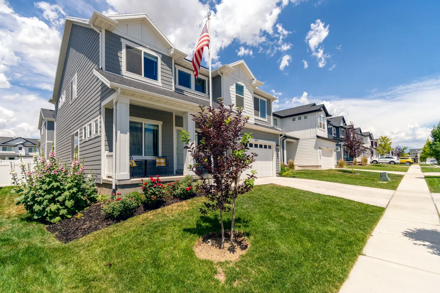
Mueller: Austin’s Walkable Master Plan
Mueller is the closest thing Austin has to a purpose-built walkable neighborhood. Developed on the site of the former Robert Mueller Municipal Airport, this 700-acre master-planned community was designed from the ground up around New Urbanist principles: narrow streets, rear-loaded garages, front porches facing sidewalks, mixed-use town centers, and parks woven throughout.
Walk Score varies by location within Mueller, generally ranging from 65 to 78 depending on how close you are to the Aldrich Street commercial district. The internal walkability, which measures how easily you can walk within the neighborhood to its own restaurants, shops, parks, and services, significantly exceeds what the score suggests. The Mueller Farmers Market (one of the largest in Austin), Thinkery children’s museum, HEB grocery store, and dozens of restaurants are all accessible on foot from most homes.
Mueller’s median home price sits at $795,000, up 3.9% year-over-year. The housing stock includes single-family homes, townhomes, row houses, and condos, with a deliberate mix of market-rate and affordable units (Mueller was one of Austin’s first large-scale developments to include mandatory affordable housing). Lot sizes are smaller than in most Austin neighborhoods, typically 3,000 to 5,000 square feet, which keeps homes closer together and enhances the pedestrian feel.
Transit is a notable strength. Mueller sits along the MetroRail Red Line, giving residents direct rail access to downtown, the Domain, and Howard Station. When Project Connect light rail opens, the MetroRail connection will feed into the larger rail network.
Best for: Buyers who want walkability without sacrificing yard space, residents with kids who want walkable access to parks and schools, and anyone who values a planned, cohesive neighborhood over organic urban development. See the Austin School Districts Guide for details on AISD schools serving Mueller.
Clarksville and Old West Austin: Quiet Walkability at a Premium
Clarksville, tucked between MoPac and Lamar Boulevard just west of downtown, carries a Walk Score in the low 80s along its eastern edge but drops into the 50s as you move west toward the bluffs. The walkable core centers on West Lynn Street and the intersection of West 6th and Lamar, where you can walk to Jeffrey’s, Josephine House, and a collection of boutiques and cafes.
This is one of Austin’s oldest neighborhoods, founded in the 1870s as a freedmen’s community. Today it is one of the most expensive, with median prices for single-family homes exceeding $1.2 million. The housing stock includes historic cottages alongside modern renovations and new construction, all on tree-lined streets with a distinctly village-like feel.
Adjacent Tarrytown carries a lower Walk Score (mid-50s) but offers a different kind of pedestrian friendliness. The neighborhood is defined by wide, tree-canopied streets where joggers, dog walkers, and cyclists are a constant presence. Tarrytown residents can walk to a small cluster of shops and restaurants along Exposition Boulevard and have easy access to the hike-and-bike trail along Lake Austin Boulevard.
Best for: High-net-worth buyers who want walkable proximity to downtown in a quiet, historic setting. Strong appeal for empty nesters downsizing from larger suburban homes who want to walk to restaurants and shops.
North Loop and Crestview: Affordable Walkability
For buyers who want walkability without a $800,000 price tag, North Loop and Crestview represent some of the best value in central Austin. North Loop carries a 67 Walk Score with an impressive 93 Bike Score, while Crestview scores 70 Walk and 87 Bike.
North Loop’s walkable spine runs along North Loop Boulevard between Guadalupe and Airport Boulevard. The stretch is lined with vintage shops (Room Service Vintage, Breakaway Records), 24-hour Epoch Coffee, Tyson’s Tacos, East Side Pies, Foreign and Domestic, and a rotating cast of food trucks. The neighborhood has a distinctly “Keep Austin Weird” vibe that has survived the gentrification wave better than most central areas.
Median home prices in North Loop sit around $575,000, making it one of the most affordable neighborhoods with a Walk Score above 65. Housing is primarily small bungalows and cottages from the 1940s-1960s, with some newer duplexes and small condo buildings.
Crestview, one block north, offers similar walkability centered around the Crestview Shopping Center (featuring Little Deli, a beloved pizza and sandwich shop) and the MetroRail Crestview Station. That rail connection adds transit value that the 52 Transit Score does not fully capture. Median prices in Crestview run $600,000 to $800,000, reflecting the slightly larger lot sizes and more substantial homes.
Adjacent Brentwood (Walk Score 70, Bike Score 83) rounds out this cluster of walkable, relatively affordable neighborhoods in north-central Austin. All three areas benefit from proximity to the Violet Crown Trail and future bike infrastructure improvements.
Best for: First-time buyers and young professionals who want walkability at a lower entry point, and anyone who values Austin’s independent, quirky retail culture.
Zilker: Walkability Meets Outdoor Recreation
Zilker scores a 75 Walk Score, which places it firmly in the “Very Walkable” category. But what the score does not capture is Zilker’s unique combination of urban walkability and immediate access to Austin’s best outdoor recreation. Residents can walk to Barton Springs Pool (68 degrees year-round, $5 admission), the Barton Creek Greenbelt trailhead, Zilker Park’s 350 acres, and the Ann and Roy Butler Hike-and-Bike Trail, all within 10 to 15 minutes on foot.
The commercial walkability centers on Barton Springs Road and the South Lamar corridor, with restaurants, grocery stores (Trader Joe’s, Natural Grocers), and entertainment venues within walking distance of most homes. The 82 Bike Score reflects the excellent trail access and bike-friendly streets.
Prices are high. Zilker’s median exceeds $900,000, with many homes above $1.2 million. The housing stock is a mix of mid-century ranch homes, 1970s cottages, and modern rebuilds. Lot sizes are generous by central Austin standards (6,000 to 10,000 square feet), and the tree canopy is mature and dense.
Ed Neuhaus, broker of Neuhaus Realty Group, notes that Zilker consistently ranks among the top three neighborhoods for buyer interest from out-of-state relocators. “People moving from walkable cities like Portland or Chicago see Zilker as the neighborhood that most closely matches what they are used to,” he says. “The combination of trail access, walkable restaurants, and proximity to downtown is hard to replicate anywhere else in Austin.”
Best for: Outdoor enthusiasts, relocators from walkable cities, and buyers willing to pay a premium for the combination of urban walkability and nature access. Also one of the best neighborhoods for remote workers who want to break up the day with a lunchtime walk to Barton Springs.
The Domain: Walkable Suburban
The Domain is Austin’s answer to a question more buyers are asking: can you get walkability without moving to central Austin?
This 304-acre mixed-use development in North Austin functions as a self-contained walkable district, sometimes called “Austin’s second downtown.” With over 3,000 residential units, three hotels, and more than one million square feet of retail, The Domain offers a pedestrian-friendly environment centered on Rock Rose Avenue, a restaurant and entertainment street designed to be walked, not driven.
Walk Score varies across The Domain, generally ranging from 60 to 75. The internal pedestrian experience is strong, with wide sidewalks, outdoor dining patios, central plazas, and covered walkways. You can walk from your apartment to Apple, Nordstrom, Whole Foods, dozens of restaurants, and entertainment venues without crossing a major road.
The limitation is that The Domain is walkable within itself but not walkable to anything beyond its borders. Step outside the development and you are on highway frontage roads surrounded by office parks. It is a walkable island in a car-dependent sea.
Prices are competitive compared to central Austin. Condo and apartment pricing ranges from $250,000 to $500,000 for ownership units, with rentals from $1,800 to $3,500 per month. The housing stock is entirely modern (the first phase opened in 2007), with apartments, condos, and townhomes.
The Domain sits along the MetroRail Red Line, providing rail access to downtown and other stations. It is also adjacent to the future North Burnet/Gateway area, which the City of Austin has designated for significant density increases. Long-term, this corridor could see walkability expand beyond The Domain’s current boundaries as infill development fills in the gaps.
Best for: Buyers who work in the North Austin tech corridor (Apple, Indeed, IBM, Amazon all have major offices nearby), retirees who want new construction and walkable retail without central Austin prices, and anyone who prefers a clean, modern, curated walkable environment.
How Walkability Affects Home Values in Austin
The price premium for walkability is real and measurable. Research from Redfin found that homes within walking distance of schools, shopping, parks, and other urban amenities sell for an average of 23.5% more than comparable properties in car-dependent areas (Source). Applied to Austin’s 2026 median home price of roughly $425,000, that premium translates to nearly $100,000 in additional value.
More granular research quantifies it at approximately $3,500 per additional Walk Score point. A home in a neighborhood with a Walk Score of 80 is worth up to $30,000 more than an identical home in a neighborhood scoring 70. At the top of the scale, homes in neighborhoods scoring 85 or higher command a 12% to 20% premium over those scoring 65, according to 2026 housing market data.
| Walk Score Range | Estimated Price Premium | Example Austin Neighborhoods |
|---|---|---|
| 90+ | +20% or more | West Campus, Downtown |
| 80-89 | +12% to +18% | East Cesar Chavez, Bouldin Creek, Holly |
| 70-79 | +8% to +12% | Hyde Park, Zilker, Brentwood, Crestview |
| 50-69 | +3% to +7% | North Loop, Allandale, South Lamar |
| Below 50 | Baseline | Circle C, Oak Hill, most suburban areas |
For investors, walkability provides a durable advantage. Walkable neighborhoods tend to hold value better during downturns because demand for convenient locations persists even when the broader market softens. During Austin’s 2022-2024 market correction, walkable central neighborhoods saw smaller price declines and faster recovery than suburban areas, according to Austin Board of Realtors data.
Walkability for Seniors and Aging in Place
Walkability is increasingly a health and independence issue, not just a lifestyle preference. For seniors, the ability to walk to a grocery store, pharmacy, doctor’s office, or community center can be the difference between aging in place and moving to assisted living.
Austin joined the World Health Organization’s Global Network of Age-Friendly Cities and Communities, signaling a city-wide commitment to pedestrian infrastructure. AARP’s Network of Age-Friendly Communities has highlighted Austin’s efforts to improve sidewalks, add pedestrian signals, and create safer crossings. CapMetro offers reduced fares for seniors at approximately half the standard rate.
The most walkable neighborhoods for seniors tend to be the same ones that score highest overall: Hyde Park, Mueller, Bouldin Creek, and downtown. Mueller deserves particular mention for seniors because of its flat terrain, wide sidewalks, ADA-compliant pedestrian infrastructure, and on-site medical offices and pharmacy.
For buyers looking at retirement in the Austin area, walkability should be evaluated not just at current ability levels but with an eye toward 10 to 20 years in the future. A neighborhood that is merely “somewhat walkable” today may become essential for daily independence later. The over-65 homestead exemption and property tax freeze make owning in a walkable Austin neighborhood more affordable for retirees over time.
Walkability with Kids
Walkable neighborhoods offer a different kind of childhood than suburban cul-de-sacs. In neighborhoods like Mueller, Hyde Park, and Crestview, kids can walk or bike to school, the park, a friend’s house, or the ice cream shop. That independence is increasingly rare in American suburbs, and research from the University of British Columbia has linked walkable neighborhoods to higher levels of physical activity and social development in children.
The key factors for evaluating walkability for households with children:
- School proximity. Can your child walk to their zoned school? In Austin, AISD schools in walkable neighborhoods include Maplewood Elementary (Crestview), Lee Elementary (Hyde Park), Zilker Elementary, Becker Elementary (Bouldin Creek), and several Mueller-area campuses. Check the Austin School Districts Guide for ratings and boundaries.
- Park access. Walkable neighborhoods with parks include Mueller (with Lake Park, Patterson Park, and the Southwest Greenway), Zilker (Zilker Park, 350 acres), Hyde Park (Shipe Park), and Bouldin Creek (Gillis Park).
- Safe crossings. Walk Score does not measure this. Walk the route yourself during school hours. Look for marked crosswalks, crossing guards, 20 mph school zones, and separated bike lanes.
- Other households with children. Mueller and Crestview have among the highest concentrations of young residents in walkable Austin neighborhoods. Hyde Park skews more toward students and young professionals.
The Future of Walkability: Project Connect and Beyond
Austin’s walkability map is about to change significantly. Project Connect, the $8.2 billion light rail system approved by voters in 2020, will add approximately 10 miles of rail connecting north Austin (via Guadalupe Street) to downtown and south to Riverside Drive. The Federal Transit Administration completed its environmental review in January 2026, and construction is expected to begin in 2027 with service opening projected for 2033.
The route will transform Guadalupe Street into a transit mall, restricting car traffic and prioritizing pedestrians and rail. Neighborhoods along the corridor, including Hyde Park, North University, West Campus, and downtown, will see their Transit Scores jump significantly. The first phase also runs along Congress Avenue and to East Riverside, a rapidly densifying area with dozens of new apartment and condo projects.
For buyers thinking about walkability as a long-term investment, the Project Connect corridor is worth studying. Neighborhoods that are currently “Somewhat Walkable” (Walk Score 50-69) but sit along or near the planned rail line could see meaningful score increases and corresponding property value appreciation over the next decade. Areas to watch include:
- East Riverside: Currently Walk Score 63, but massive redevelopment and the planned light rail station could push this into the 70s or 80s. Entry prices remain relatively affordable at $300,000 to $500,000 for condos.
- North Lamar corridor: Currently Walk Score 56, the corridor between The Domain and downtown will benefit from MetroRail improvements feeding into the light rail network.
- South Congress beyond Oltorf: Walk Score drops quickly south of Ben White Boulevard, but zoning changes under HOME Initiative are enabling denser, more walkable development along the corridor.
The city’s $460 million Prop B investment is also adding over 200 miles of protected bike lanes and urban trails through 2030, which will boost Bike Scores across the metro. Combined with light rail, Austin’s walkability and transit infrastructure in 2035 will look fundamentally different than it does today.
How to Evaluate Walkability When House Hunting
Walk Score is a starting point, not the final answer. When evaluating a specific home’s walkability, go beyond the number.
Walk the routes yourself. Pick three to five places you would visit weekly (grocery store, coffee shop, gym, park, school) and actually walk the route from the home’s front door. Time it. Note the sidewalk condition, shade, traffic crossings, and whether the route feels safe.
Check multiple times of day. A neighborhood that feels walkable on a Saturday morning may feel different at 9 PM on a Tuesday. Walk at night if you plan to walk at night.
Test the summer. Austin’s walkability changes dramatically between October and June. A 15-minute walk to the grocery store in March becomes a punishing slog in August without tree cover. Neighborhoods with mature canopy (Hyde Park, Clarksville, Tarrytown, Zilker) score higher on the “real” walkability scale than newer neighborhoods with young trees.
Check the grocery situation. This is the single most important amenity for walkable living. Can you walk to a full-service grocery store? In Austin, neighborhoods near H-E-B, Whole Foods, Fresh Plus, or Natural Grocers locations have a significant walkability advantage.
Look at the bike infrastructure. Even in walkable neighborhoods, you will sometimes need to cover two to three miles (too far to walk, too short to drive). A good Bike Score and nearby trail access extends your car-free radius dramatically. With e-bikes, a Bike Score of 70+ effectively doubles the walkable range of a neighborhood.
Talk to residents. Ask people who actually live in the neighborhood how often they walk versus drive. The answers will tell you more than any score. Ed Neuhaus of Neuhaus Realty Group recommends that every buyer spend a full day in a neighborhood before making an offer, including walking to three places they would visit regularly.
The Walkability-Affordability Trade-Off
Austin’s most walkable neighborhoods are also among its most expensive. That is not a coincidence. The premium for walkability reflects genuine scarcity: central Austin’s walkable core is geographically constrained, bounded by highways, the river, and existing development. Supply cannot easily expand.
For buyers on a budget, the strategy is to find neighborhoods where walkability is improving rather than established. The best current opportunities:
- Rosewood (Walk Score 70, median $400K-$650K): Adjacent to East Austin’s walkable core, with prices significantly lower than East Cesar Chavez.
- Upper Boggy Creek (Walk Score 73, median $475K-$700K): Strong Walk and Bike Scores with access to the Boggy Creek Greenbelt.
- North Loop (Walk Score 67, median $575K): The most character per dollar of any walkable Austin neighborhood.
- Chestnut (Walk Score 78, median $450K-$700K): High walkability at prices below neighboring Hyde Park.
For the lowest entry point into walkable Austin living, condos in West Campus ($350K-$500K), downtown ($400K-$700K), and the Domain area ($250K-$500K) offer the highest Walk Scores at the most accessible prices. See the condo buying guide for details on HOA fees, reserves, and what to look for.
Buyers considering suburban communities west of Austin should understand that walkability drops to near zero. Cost of living is lower in places like Bee Cave (Walk Score 24), Lakeway (Walk Score 11), and Dripping Springs (Walk Score 6), but those savings are partially offset by higher transportation costs. The average Austin household spends $12,200 annually on transportation, according to the Bureau of Labor Statistics. In walkable neighborhoods, that number can drop to $6,000 to $8,000 for households that eliminate one car.
Austin’s Walkability Compared to Other Cities
Where does Austin stand nationally? Walk Score ranks Austin the 30th most walkable large U.S. city, behind most major coastal cities but ahead of many Sun Belt peers (Source).
| City | City-Wide Walk Score | Most Walkable Neighborhood |
|---|---|---|
| San Francisco | 87 | Chinatown (99) |
| Chicago | 78 | Near North Side (97) |
| Portland | 65 | Pearl District (96) |
| Denver | 61 | LoDo (95) |
| Nashville | 28 | Downtown (81) |
| Austin | 42 | West Campus (92) |
| Dallas | 46 | Uptown (89) |
| Houston | 36 | Midtown (85) |
| San Antonio | 38 | Downtown (78) |
The comparison reveals something important. Austin’s best walkable neighborhoods (Walk Score 80+) compete with the best in any American city. The difference is that Austin’s walkable core is small. In cities like Chicago or San Francisco, you can find Walk Scores above 70 across dozens of neighborhoods. In Austin, you are limited to roughly 15 to 20 neighborhoods, most of them within five miles of the Capitol building.
For relocators coming from walkable cities, this guide should help narrow the search. If you are moving to Austin from a city where you currently walk everywhere, focus your home search on the neighborhoods listed in the ranking table above. Anything below Walk Score 65 will feel dramatically more car-dependent than what you are used to.
Frequently Asked Questions
Finding the Right Walkable Neighborhood for You
Walkability means different things to different buyers. For some, it is the ability to walk to a world-class restaurant on a Friday night. For others, it is walking a child to school on a Tuesday morning, or walking to a pharmacy without asking someone for a ride. Austin’s walkable neighborhoods span a wide range of prices, housing types, and lifestyles.
Start with what you actually walk to. If it is restaurants and nightlife, downtown and East Austin are your best bets. If it is parks and trails, Zilker and Mueller. If it is a grocery store and a coffee shop, Hyde Park, North Loop, and Crestview deliver that at a more accessible price point.
Then layer in budget, housing type, school district, and how much you are willing to pay for walkability today versus buying into an area where walkability is coming (East Riverside, the Project Connect corridor). For a broader neighborhood comparison, see the Austin Neighborhoods by Lifestyle Guide, and for help evaluating specific properties, contact Neuhaus Realty Group for a neighborhood walkability assessment tailored to your priorities.


